Vegetation and environment in and around the Reinberg basin (Vorpommern, NE Germany) during the Weichselian late Pleniglacial, Lateglacial, and Early Holocene
In the context of the priority program “Changes of the geo-biosphere during the last 15,000 years” of the Deutsche Forschungsgemeinschaft (DFG), geomorphological studies in NE Germany focussed on the reconstruction of Lateglacial and late Holocene slope erosion processes (Helbig 1999a/b; Helbig et al. 2002). One of the selected study areas was a kettle-hole in the surroundings of Reinberg. A fossil Ah-horizon on top of Pleniglacial basin sands (the “Reinberg horizon”) – dated to 14271-14600 cal BP – contains a pollen record of a local vegetation at the trnasition from the Weichselian Pleniglacial to Lateglacial. This discovery triggered combined palynological, diatomological, and geomorphological research.
 Location of the Reinberg basin (R) in northern Mecklenburg-Vorpommern
Detailed palynological and macrofossil analyses of short sections from the Reinberg horizon revealed a number of plant taxa that grew locally within the basin during a period with in general low water levels, including a.o. sedges, grasses, Armeria, Plantago, Parnassia, Batrachium, Ranunculus sceleratus, Caryophyllaceae, Juncus, Equisetum, Lactucaceae, and Sphagnum. Since these taxa include both typical dryland taxa and typical wetland taxa as well as a number of taxa that might originate from both wet and dry environments, it is concluded that an environment of shallow wet ponds and low dry mineral domes existed within the basin at the transition between the Pleniglacial and the Lateglacial with probably water level changes over the year.
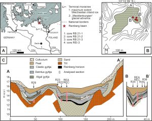 Cross-section through the Reinberg basin and location of the analysed sections
Combined palaeoecological and sedimentological analyses of core “Reinberg C” (REC) allowed the reconstruction on the interaction between vegetation and environment during the Lateglacial and provides a detailed palaeoenvironmental dataset. Rising water levels at the beginning of the Lateglacial drowned the environment of the Pleniglacial-Lateglacial transition and a lake was formed.
The Lateglacial vegetation development started with a phase with an open dryland vegetation, the Open vegetation phase I (“OldestDryas”, or earlier part of the “Meiendorf”) and is followed by the Hippophaë phase, a period with prominent presence of sea-buckthorn (“Bølling”). This phase is followed by Open vegetation phase II, a second phase with a more open upland vegetation (“Older Dryas”). The sediment parameter, together with the reconstructed vegetation, point to a gradual shift to a more humid climate. Deposition of CaCO3 ceased in the Reinberg basin during the Hippophaë phase, probably because decalcification of the surrounding basin slopes had proceeded to such depth that the inteflow (that feeded the basin) had become deprived of lime.
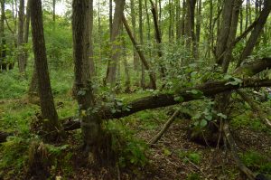 View of the Reinberg Basin, currently vegetated with an alder carr, at the approximated site of core Reinberg C (REC)
During the Lateglacial Betula/Pinus forest phase (“Allerød”) mainly birch forests dominated the dryland. Soil erosion had largely stopped and organic sediments were deposited. Four subphases are distinguishable that are based on fluctuations in the curves of pollen attributable to birch and pine. A prominent pollen fluctuation occurs directly above the Laacher See tephra (see environmental impact of the Laacher See eruption on the landscape of NE Germany). Towards the end of the forest vegetation phase, a floating vegetation mat stretched on the water surface that was drowned shortly after the onset of the last open vegetation phase of the Lateglacial.
Open vegetation phase III (“Younger Dryas”) shows a tripartite opening-up of the upland vegetation. The vegetation was denser and soil erosion was less severe than during the early vegetation phases of the Lateglacial. During this phase aquatic Ranunculaceae were prominent within the basin. At the transition to the Holocene a prominent lowering of water levels caused the destruction and/or removal of the upper Lateglacial sediments. After water levels rose again, a peatland developed in the basin during the Early Holocene.
The Holocene sequence of core REC shows a considerable anthropogenic disturbance due to peat extraction in the late or post Medieval. Afterwards, regeneration took-place.
Publications including palaeoecological data from the Reinberg basin
De Klerk, P. (2003): Additional AMS 14C-dates from the Reinberg basin (Vorpommern, NE Germany): Supplemental report to DFG project Bi 560/1-5 “Präzisierung der frühesten Vegetationsentwicklung anhand der Lokalität Reinberg”. Project Report, Geographical Institute, Ernst-Moritz-Arndt-University Greifswald, 5 pp.
De Klerk, P. & Helbig, H. (2001): Präzisierung der frühesten Vegetationsentwicklung anhand der Lokalität Reinberg. Project Report, Geographical Institute, Ernst-Moritz-Arndt-University Greifswald, 16 pp. + appendices.
De Klerk, P., Helbig, H., Helms, S., Janke, W., Krügel, K., Kühn, P., Michaelis, D. & Stolze, S. (2001): The Reinberg researches: palaeoecological and geomorphological studies of a kettle hole in Vorpommern (NE Germany), with special emphasis on a local vegetation during the Weichselian Pleniglacial/Lateglacial transition. Greifswalder Geographische Arbeiten 23: 43-131.
De Klerk, P., Helbig, H. & Janke, W. (2008): Vegetation and environment in and around the Reinberg basin (Vorpommern, NE Germany) during the Weichselian late Pleniglacial, Lateglacial, and Early Holocene. Acta Palaeobotanica 48: 310-324.
De Klerk, P., Janke, W., Kühn, P. & Theuerkauf, M. (2008): Environmental impact of the Laacher See Eruption at a large distance from the Volcano: integrated palaeoecological studies from Vorpommern (Germany). Palaeogeography, Palaeoclimatology, Palaeoecology 270: 196-214.
Helbig, H. & de Klerk, P. (2002): Geoökologische Prozesse des Pleni- und Spätglazials in der Hohlform “Reinberg”, Nordvorpommern. Greifswalder Geographische Arbeiten 26: 31-34.
Theuerkauf, M. (2003): Die Vegetation NO-Deutschlands vor und nach dem Ausbruch des Laacher See-Vulkans (12880 cal. BP). Greifswalder Geographische Arbeiten 29: 143-189.
Related publications:
Helbig, H. (1999a): Die spätglaziale und holozäne Überprägung der Grundmoränenplatten in Vorpommern. Greifswalder Geographische Arbeiten 17: 1-110.
Helbig, H. (1999b): Die periglaziäre Überprägung der Grundmoränenplatten in Vorpommern. Petermanns Geographische Mitteilungen 143: 373-386.
Helbig, H., De Klerk, P., Kühn, P. & Kwasniowski, J. (2002): Colluvial sequences on till plains in Vorpommern (NE Germany). Zeitschrift für Geomorphologie N.F., Supplementbände 128: 81-100.
Theuerkauf, M. (2002): Die Laacher See-Tephra in Nordostdeutschland: Paläoökologische Untersuchungen mit hoher zeitlicher und räumlicher Auflösung. Greifswalder Geographische Arbeiten 26: 171-174.
Your e-mail address will not be published.