Palaeoecological research in the Dubringer Moor (Dubring Mire, E Germany)
In the search for pollen diagrams from NE Germany for the study of patterns in vegetation and sedimentation during the Weichselian Lateglacial it was discovered that many unpublished palynological data from the period of the German Democratic Republic are preserved in archives of research institutes. In order to save these data from sinking into oblivion and to make them available to the scientific audience, part of this material was digitalised and published (see revision of old palynological data from E Germany). One of palynologically analysed profiles by the late Klaus Kloss is from the Dubringer Moor.
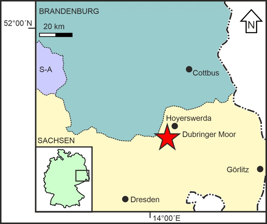 Location of the Dubringer Moor near Hoyerswerda in the federal state Saxonia (Sachsen)
The Dubringer Moor is one of the most important mires of the German Federal State Sachsen (Saxonia). It has been threatened for the major part of the Twentieth Century by open-cast mining, which partly triggered scientific research in order to gain knowledge on the area before it would be lost forever. Although the mire became a nature conservation area in 1972 that was expanded in 1981, it also became part of a mining priority area in 1981. Between 1983 and 1985 extensive geoscientific research was carried out to investigate the economic potentials of large-scale peat extraction (Buchholz et al. 1985). The threats to the mire did not disappear prior to the political changes in the German Democratic Republic in 1989/1990.
Currently the research of the Dubringer Moor is extended with the processing of data from the unpublished report from Buchholz et al. (1985) including 15 lithological cross-sections and 9 pollen diagrams.
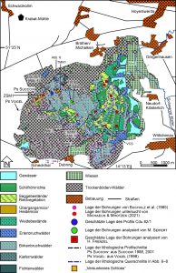 Vegetation map of the Dubringer Moor (from De Klerk & Joosten 2016, after Vogel 1998) with location of all cores, cross-sections and palynologically analysed peat profiles available at present.
The Dubringer Moor is positioned along the slope of the Lausitzer Urstromtal (currently occupied by the Schwarze Elster River). Lignite occurs already at a relatively shallow depth of 5-20 m, and its contraction resulted in the formation of several channel-like basins where peat formation initiated. The mire is surrounded by Saalian terminal moraines in the south, west and north, with an opening to the east. The western/northwestern upslope part of the mire complex consists of extensive birch carrs and bog-like patches. This part of the mire is fed by springing groundwater from the sandy moraines. The large mire complex consists of several hydrogenetic mire types that in time and space gradually graded into each other.
The mire has been used excessively by humans. An important archaeological monument is the c. 2500 year old Iron Age fortification “Versunkene Schloss” (“submerged Castle”) in the south of the mire. Of more recent date are numerous ditches aimed to drain the mire, whereas also several mills around the peatland affected mire hydrology in the past. Furthermore, peat extraction has been prominent, and many small patches of open water in the northwestern area are former peat pits. The various large ponds in the east are fish farms from nearby monasteries that were initiated during the 16th and 17th centuries with currently expanding reed marshes. Many meadows lay especially along the outermost parts of the Dubringer Moor.
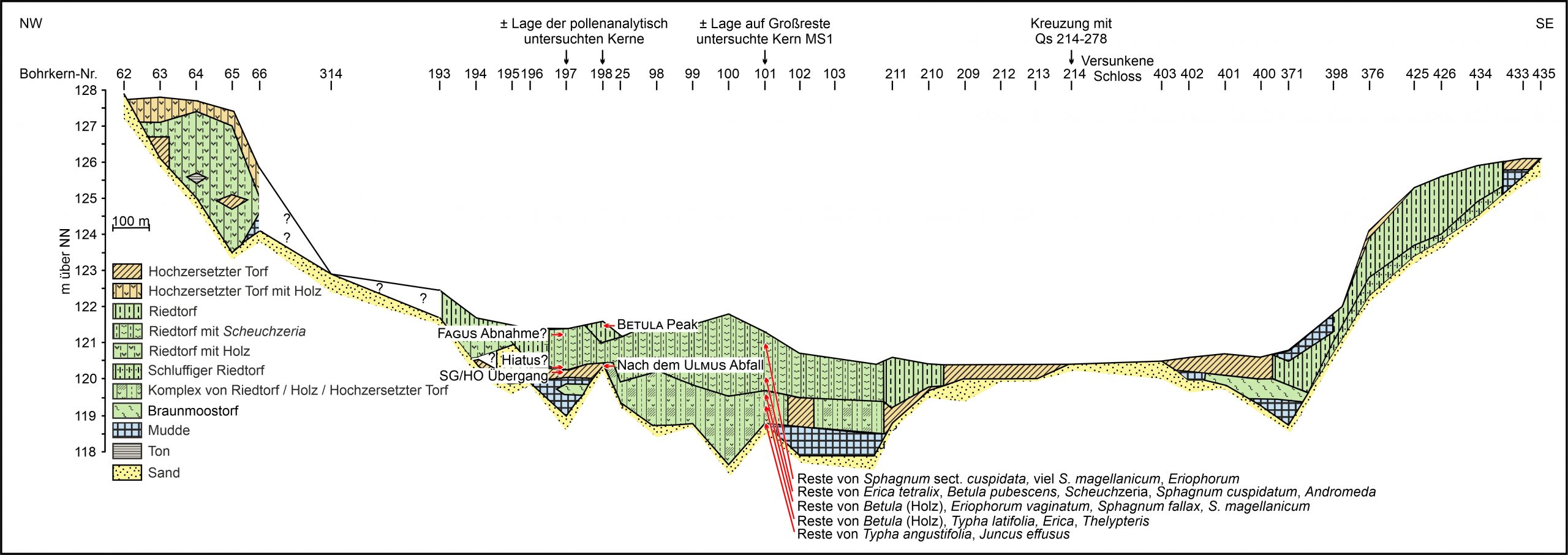 Cross-section through the Dubringer Mire from the northwestern to the southeastern slopes showing the complex of different peat types. Constructed after the lithological data of Buchholz et al. (1985) based on data and permission from the Sächsisches Landesamtes für Umwelt, Landwirtschaft und Geologie (Freiberg).
The pollen diagrams cover the final time-frame of the Weichselian Lateglacial and the complete Holocene, however there are possibly some small hiatuses. Whereas in the upper northwestern parts of the mire springmires existed that developed into bog-like patches, the lower eastern parts of the mire developed out of one large lake and various small ponds into alder/birch carrs. The mire parts inbetween contain peat directly on the mineral subsoil: the regions along the slope may have developed as sloping mires developing into percolation mires. After artificial drainage the mire dried, the alder carrs disappeared greatly and much drier birch stands expanded.
This research is carried-out in close cooperation with Olaf Tietz and Hans Joosten.
Publication:
De Klerk, P. & Joosten, H. (2016): Vegetation history and mire development in the northwestern part of the Dubringer Moor near Hoyerswerda (Sachsen, E Germany) inferred from a pollen diagram from the legacy of Klaus Kloss. Mauritiana 30: 77-95.
De Klerk, P., Tietz, O. & Joosten, H. (2022): Paläoökologische Forschungen im Dubringer Moor bei Hoyerswerda (Sachsen): eine Neubearbeitung alter Daten. Berichte der naturforschenden Gesellschaft der Oberlausitz 30: 131-148.
Selected other publications on the Dubringer Moor:
Buchholz, F., Mehlhorn, M., Böhme, L. & Seifert, M. (1985): Torf Dubringer Moor. Ergebnisbericht mit Vorratsberechnung. Unpublished report, VEB GFE Freiberg.
Jorga, W. (2000): Das Dubringer Moor. Oberlausitzer Familien-Kalenderbuch 2001: 83-86.
Karneth, S. (1990): Zur historischen Gebietsentwicklung im heutigen Naturschutzgebiet „Dubringer Moor“ und dessen enger Umgebung. Abhandlungen und Berichte des Naturkundemuseums Görlitz 64: 37-41.
Kloss, K. (1990): Beitrag zur Moor- und Vegetationsgeschichte des Dubringer Moores, Kreis Hoyerswerda, nach einem Pollendiagramm. Abhandelungen und Berichte des Naturkundemuseums Görlitz 64: 33-36.
Neumann, E.E. (1990): Die bodengeologischen Verhältnisse des Dubringer Moores Inventarisierung und Hinweise für die Arbeit im Naturschutz. Abhandlungen und Berichte des Naturkundemuseums Görlitz 64: 27-31.
Pietsch, W. (1985): Vegetation und Standortverhältnisse der Heidemoore der Lausitz. Verhandlungen der Zoologisch-Botanischen Gesellschaft in Österreich 123: 75-98.
Pietsch, W. (1990): Pflanzengesellschaften und Standortverhältnisse im Naturschutzgebiet „Dubringer Moor“. Abhandlungen und Berichte des Naturkundemuseums Görlitz 64: 43-49.
Seifert, M. (1995): Die Vegetationsentwicklung des Dubringer Moores. Report, Sächsisches Landesamt für Umwelt und Geologie, Freiberg.
Succow, M. (1981): Landschaftsökologische Kennzeichnung und Typisierung der Moore der DDR. PhD-Thesis, Eberswalde.
Succow, M. (2001): Durchströmungsmoore. In: Succow, M. & Joosten, H. (eds.): Landschaftsökologische Moorkunde. E. Schweizerbart’sche Verlagsbuchhandlung (Nägele u. Obermiller), Stuttgart: 365-378.
Vogel, J. (1998): Das Dubringer Moor. Staatliches Umweltfachamt, Bautzen/Naturforschende Gesellschaft der Oberlausitz e.V., Görlitz.
Vogel, J. (2008): Dubringer Moor. In: Naturschutzgebiete in Sachsen. Sächsisches Staatsministerium für Umwelt und Landwirtschaft, Dresden: 146-153.
Wetzel, G. (1992): Die Siedlungsgeschichte im Kreis Hoyerswerda bis zum Mittelalter. In: Hoyerswerda, Geschichte und Geschichten aus Dörfern und Städten. Geiger-Verlag, Horb am Neckar: 22-31.
Zscharnack, G. (1992): Das Naturschutzgebiet Neudorf-Dubringer Moor. In: Hoyerswerda, Geschichte und Geschichten aus Dörfern und Städten. Geiger-Verlag, Horb am Neckar: 70-81.
Your e-mail address will not be published.
It is a beautiful peatland!