Vegetation history around the basin Horst 2 (NE Germany)
Small kettle-holes, so-called “Sölle”, belong to the most prominent landscape elements within the till plains of NE Germany. Many of them originate from the melting of buried dead-ice of the Weichselian glaciation, but many are the result of other glacial processes or are of anthropogenic origin. In the context of the priority program “Changes of the geo-biosphere during the last 15,000 years” of the Deutsche Forschungsgemeinschaft (DFG), geomorphological studies in NE Germany focussed on the reconstruction of Lateglacial and Holocene slope erosion processes of such small kettle-holes (Helbig 1999a/b; Helbig et al. 2002).
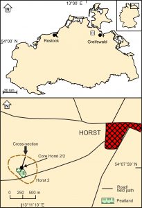 Location of the basin “Horst 2” in northern Mecklenburg-Vorpommern (NE Germany)
One of the selected study areas was a kettle-hole in the surroundings of Horst. The sediments in the basin include (bottom to top) silt gyttja, detritus gyttja, algal gyttja, brownmoss peat, peaty gyttja, detritus gyttja, peat, and a covering colluvium. The wide extension of peat below the colluvium shows that the peatland in the basin has been substantially larger in previous times. In order to coarsely date the sediment sequence, a rough pollen diagram of core “Horst 2/2” was prepared.
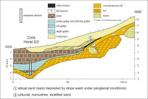 Cross-section through the basin “Horst 2”
The pollen diagram shows some remarkable pecularities that do not occur in other pollen diagrams from northern Vorpommern covering the Lateglacial, e.g. a peak of pollen attributable to dwarf birches in the middle part of the Lateglacial Betula/Pinus forest phase (Allerød), an increase in pollen attributable to pine at the end of this vegetation phase, and the absence of a peak of pollen attributable to Empterum in Open vegetation phase III (Late Dryas) (for the vegetation phases of Vorpommern, see the section on the Endinger Bruch area).
The Laacher See tephra occurs in peat but is covered by a thin layer of detritus gyttja that indicate a short-lived phase to a shallow aquatic environment that may be the result of severe rainstorms after the volcanic eruption that temporarily flooded the peatland (see the impact of the Laacher See eruption on the landscape of NE Germany).
The pollen diagram will be added soon
There is a sharp transition from the detritus gyttja to the covering brownmoss peat, indicating that a hiatus separates the Lateglacial sequence from the Holocene. The pollen spectra show that the complete Early Holocene Betula/Pinus forest phase (Preboreal) is absent. This hiatus represents probably a sudden lowering of water levels at the beginning of the Holocene due to which some of the previously deposited sediments were destroyed. A similar hiatus at the beginning of the Holocene is observable at several other sites in northern Vorpommern (cf. De Klerk 2004).
These characteristics can be attributed to the small size of the basin, due to which mainly (extra)local pollen deposition of the vegetation immediately surrounding the basin is registered. The pollen diagram and the inferred vegetation history, therefore, only have value for the direct surroundings of the basin and have limited overregional significance. They provide, however, valuable insights in the Lateglacial vegetation directly surrounding a small basin within the till plains.
This research was carried out in close cooperation with Henrik Helbig.
Publications:
De Klerk, P. (2004): Changes in vegetation and environment at the Lateglacial-Holocene transition in Vorpommern (Northeast Germany). Internationale Archäologie – Arbeitsgemeinschaft, Tagung, Symposium, Kongress 5: 27-42.
De Klerk, P. & Helbig, H. (2006): A pollen diagram from a kettle-hole near Horst (Vorpommern, NE Germany) covering the later part of the Weichselian Lateglacial. Zeitschrift für geologische Wissenschaften 34: 379-387.
De Klerk, P., Janke, W., Kühn, P. & Theuerkauf, M. (2008): Environmental impact of the Laacher See Eruption at a large distance from the Volcano: integrated palaeoecological studies from Vorpommern (Germany). Palaeogeography, Palaeoclimatology, Palaeoecology 270: 196-214.
Related publications:
Helbig, H. (1999a): Die spätglaziale und holozäne Überprägung der Grundmoränenplatten in Vorpommern. Greifswalder Geographische Arbeiten 17: 1-110.
Helbig, H. (1999b): Die periglaziäre Überprägung der Grundmoränenplatten in Vorpommern. Petermanns Geographische Mitteilungen 143: 373-386.
Helbig, H., De Klerk, P., Kühn, P. & Kwasniowski, J. (2002): Colluvial sequences on till plains in Vorpommern (NE Germany). Zeitschrift für Geomorphologie N.F., Supplementbände 128: 81-100.
Your e-mail address will not be published.